501-918-3025
calsfoundation@cals.org
calsfoundation@cals.org
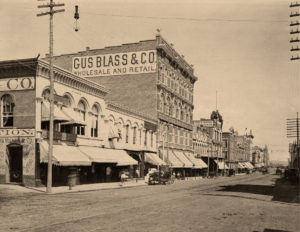
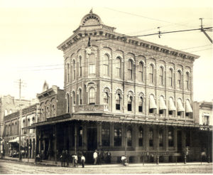
Have you ever looked around downtown Little Rock and wondered about its architectural history? Perhaps you’ve seen some of the vacant spaces and thought to yourself, “I wonder what used to be there?” Well, now some of those questions can be answered. The CALS Butler Center for Arkansas Studies has created a mapping project that utilizes Google Earth to reveal the architectural history of downtown Little Rock. Images from the Butler Center’s collections are juxtaposed against modern images from Google Earth, resulting in a virtual tour that allows you to see how the downtown landscape has changed over the years.
Most of the buildings shown in images from our collection no longer exist. The earliest images in the project date from the Civil War, while the more recent ones document the revitalization and urban renewal that took place in the 1950s and 1960s. One of the most striking photographs is an aerial view taken around 1929. What immediately stands out is how full the landscape is in the 1929 view compared to the modern view. Back then, most of the downtown area was taken up with structures. Of course, that was before automobiles were as common as they are now. Many spaces that once housed buildings later became parking lots, with the buildings demolished to make way for them. (Note: When viewing the project, be sure to click on the historical images so that you can make them larger and see more detail.)
In putting together the project, staff used city directories and Sanborn insurance maps to plot the locations of the photographs – many of which lacked specific locations – onto Google Earth. In the planning stages, staff discussed and debated the geographic boundaries of “downtown.” In the end, the definition was interpreted broadly, though the bulk of the images utilized come from the main thoroughfares. The project focuses on the commercial history of the area and purposely avoids private residences, although at some point down the road, we may develop a separate project on the residential history of downtown. We might also expand the project to encompass the history of the commercial areas through the 1970s and 1980s, allowing us to show how the construction of I-630 changed the downtown landscape.
We hope this project leads to a better understanding of how the built history of downtown has evolved over the years. Although digitizing and putting online the more than 200,000 images in the Butler Center’s collection is a work in progress, projects like this allow us to harness the power of modern technology to connect people with the past in new ways and showcase some of the hidden gems in our collection.